Vinalhaven: an exposed magma chamber
Geology of Vinhalhaven Island, Maine
An Ancient Volcanic Magma Chamber
Or, strange pillows and rock snow cones
Bruce Oldfield
Professor, Geology, BCC
Introduction
Vinhalhaven is the largest island of the Fox Islands in Penobscot Bay, Maine. It lies about an hour east of Rockland Maine (15km, 9 miles) by ferry. Vinalhaven has been an important producer of granite products in the 19th and early 20th Centuries. Today, the island is an important lobster fishing port. The granites were used for the base of the Brooklyn Bridge, Washington Monument and Federal Office Buildings in the Capitol. The eight huge polished columns for the nave of the Cathedral of St. John the Divine in NYC, the PRR Station and Masonic Temple in Philadelphia and many private mansions, monuments, bridges and dams were built with the fine Vinalhaven granites.
Geologic Setting
These granites formed as the result of cooling of a magma chamber from a volcano that erupted approximately 400 million years ago as part of the Acadian Orogeny. The Coastal Maine Magmatic Province includes a series of islands including Vinalhaven and Mount Desert Island that comprises Acadia National Park. There are over 100 different plutons (magma chambers) along the southern Maine Coastline. The members of this province represent the magma chambers volcanoes that erupted in the late Silurian, Early Devonian Periods. The presence of quarries and sea-swept shorelines means that the rocks are very accessible at the present surface. To be perfectly clear early on, what we are seeing at the surface of the Earth today would have been miles underground, with very tall volcanoes atop. Erosion has removed many miles of the crust to expose the roots of these volcanoes.
These plutons are thought to be formed after microplates of continental crust (terranes) accreted onto the North American craton. Most of the granitic plutons are only a few miles thick and lie above a mafic (basaltic) basement. The surrounding “country” rocks are now contact metamorphosed volcanic rocks that probably contain some of the eruptive materials from these ancient volcanic eruptions. The magma chambers may have taken as long as tens of millions of years to cool. These volcanoes were erupting at the same time that some of the rocks of NYS were deposited from material eroding of the mountains in New England.
The post accretion volcanism seen along the coast of Maine may represent a stretching of the Avalonia terrane that was sutured to North American during the Acadian Orogeny. This stretching of the crust encouraged magma, both silica-rich and mafic-rich to rise along faults towards the surface. The volcanoes that formed in this area may have constructed a mountain chain rivaling the Andes Mountains in stature.
The Magma Chamber
The magma chamber at Vinalhaven Island (henceforth referred to as Vinalhaven pluton or just pluton) is exposed all the way around the island and evidence from these rocks indicate that the chamber has been tilted downward slightly (10 – 30 degrees) in northwestern direction. This means that the rocks exposed along the southern and western edges represent the bottom of the chamber, the rocks along the northern and eastern coast of Vinhalhaven represent the top of the magma chamber.
The pluton consists of four main units:
1. The largest is a coarse-grain pinkish biotite granite, the most extensive rock unit on the island.
2. A gabbro-diorite (coarse-grain, dark, ferromagnesian-rich (mafic), silica poor igneous rock) that consist of sheets that intermingle with granite rocks. These layers show distinctive “pillow” structures that have cores of gabbro/basalt (dark colored igneous rocks that sometimes are fine-grained,other times coarse-grained) that are surrounded by coarse-grain granites. This rock will be referred to as basalt and/or mafic throughout this paper.
3. A finer-grain, whitish granite. This unit forms a smaller body that intrudes across the coarse-grain granite and gabbro-diorite units (units 1 and 2 above). This granite represents replenishment of the silicic (silica-rich) granite into inner core of the chamber.
4. Large to small pieces (from centimeters to a hundred meters) of metamorphosed country rocks. These pieces are metavolcanics what we would call rhyolites (fine grained, pinkish igneous rocks, high in silica), and are probably former volcanic ashes and breccias. Locally referred to as the Calderwood Formation. These rocks have been metamorphosed to the greenschist facies and minerals such as cordierite (Iolite (water sapphire), andalusite (another gemstone) and hypersthenes form.
The coarse-grain pinkish granite (Unit 1) represents the main magma body of the pluton. After this part of the pluton cooled, the finer-grain whitish granite (Unit 2) was emplaced. This represents a replenishment of the silicic magma. Later, the mafic basalt intrusions (Unit3) seeped into the floor of the chamber. At the end of the eruptive cycles, the roof of the magma chamber collapsed to form a caldera, a large circular hole in the volcanic structure.
Magma Floor
The mafic, basaltic magma (Unit 2) flowed into the bottom of the chamber where there was a ‘slush’ of granitic component crystals (Unit 1). This slush is composed of cooling magma that is partially crystallized feldspar, quartz and biotite and cooling molten rock. This slush would eventually cool to the pinkish coarse-grain granite. The state of this magma is significant. Think of a snowcone, part ice, part fluid. With the magma chamber the temperature isn’t 0deg Centigrade like the snow cone, rather it’s quite warm perhaps 1,000 – 1200 deg Centigrade.
As the granite was cooling and biotite, feldspars and quartz crystals were forming, the mafic magma intruded into this slush. The warmer mafic magma flowed as a cohesive flow in some places , whereas in other places it melted the granite and comingled with the granite. The basalt flowed up narrow dikes through hardened granite but spread out and pooled on the bottom of the magma chamber. Where the mafic flows remained cohesive, they formed pillows or blobs of dark colored masses that range from less than a meter up to several meters thick and long. The granite slush was squeezed between the pillows and now outline the dark pillows with bright white, sometimes pink crusts.
This replenishment of the silicic (original) magma by the mafic magma occurred incrementally over 500,000 to 1,000,000 years. The emplacement of the basaltic flows look very much like sedimentary sequences but with alternating basaltic zones (Unit 2) and granitic zones (Unit 1).
There are four pillow mounds on the island (I visited one). Each mound was likely fed by a single pulse of basaltic magma because there is little chemical variation with any mound. The forms and sizes of the pillows and tubes in each mound are similar and it’s possible to recognize connections between sheets, tubes and pillows.
Chamber Roof
The northwest corner of the island has rhyolitic (fine-grain, silica rich rocks that typically represent volcanic ash accumulations) rocks that indicate this is the roof of the chamber. The rhyolites contain pyroclasts from volcanic eruptions. Besides these pieces of volcanic ejecta, fall debris, lahars (mudflows of volcanic material) and other surficial features are present. These rocks represent an area where the roof of the volcano collapsed into magma below preserving evidence of what the surface, extrusive features of the volcano may have looked like.
Although the next feature is not necessarily from the chamber roof, large blocks of country rock in the rock on the eastern side of the island give us a look at the native, country rock that the pluton intrude into. A many places along the eastern coast and interior large (up to several meters in length) blocks of the native country rock are found embedded in the granite. Some of these represent parts of the sides and top of the volcano that collapsed during the caldera formation. After a magma body is spent, a large explosion can blow off the top of the volcano and the top and sides collapse into the remaining magma. Alternatively, the remaining magma can cool and shrinks leaving a large cavity near the top of the chamber to which the top and sides collapse in the cooling magma. These blocks of metamorphosed country rocks are very numerous in many locations indicating that collapse occurred.
What makes Vinalhaven worthy of your attention?
First of all, the island’s surrounding, exposed shoreline allows introductory students to see evidence of the structure of a magma chamber. There are few places in the world where the roots of mountains, detailed geologic structures such as this magma chamber are clearly visible. Vinalhaven represents the root of a volcano that originally was up to 15,000 feet tall and now has eroded down so we can observe conditions that are several miles below sea level.
Secondly, even as late as 1999, geologists thought that magma chambers formed as completed units and Vinalhaven shows that magma chambers cannot only be replenished, they can be replenished with a very different types of magma (granite for one, a mafic gabbro/basalt for another). Geologists previously thought that in this geologic setting (not necessarily a model for all types of volcanoes) magma bodies (diapirs) flowed upwards towards the surface as single, slowly emplaced bodies. The composition of the Vinalhaven pluton is bimodal, it has both silicic (silica-rich) and mafic (ferromagnesian, iron and magnesium-rich) which is unusual and not well documented in past research.
Thirdly, previously geologists thought that pillow basalts formed only in watery, typically oceanic environments. When basaltic magma oozes from the mid-ocean ridges, or lava flows into a body of water, the basalt forms in discrete pillow-like shapes. Pillow basalts were previously thought to only form in water. At Vinalhaven, we have indisputable evidence of pillow basalts forming at the bottom of a water-free magma chamber. Conditions at the time of the bottom were such that the magma was undergoing crystallization and solid crystals and liquid magma coexisted. The basalt flows behaved in this slushy (very hot, not cold) environment to form the same type of structures we see in typical watery environments. There is a significant difference of course, the presence of the granite slush filling the spaces between the pillows is very different from what we see in water produced pillows.
I have to say that I couldn’t have picked a better pluton to study. I have been to (and hope to return on this trip) to Acadia National Park that has yet another pluton exposed, but the pillows at Vinalhaven and the complete exposure of the chamber was exceptional.
I am deeply indebted to the works of R.A.Wiebe, H.Frey, D.P.Hawkins and many others who through the Keck Symposium have done much research and encouraged much undergraduate research on Vinalhaven geology.

Introduction to Taconic Mountains
Taconic Mountains
The Taconic Mountains are a group of formerly large volcanic islands that were fused with the ancient North American Continent during the Ordovician Period of geologic time. The mountain building spans from about 450 million to 440 million years ago. The Taconic Mountains are bordered by Emmon’s line (see image) on the west side, literally running through the RPI campus in Troy NY to Cameron’s line on the east side in Connecticut.
Before we get to far into the geology of New England, I need to define a few terms. A craton is the original nucleus of the continents. Cratons, continental nuclei, started early in the Earth’s history (over 4 billion years ago) and grew in size by two main processes: sediment eroding off the craton onto the edges (continental shelves) and having other land masses fused to their edges. These other land masses are often referred to as exotic terranes as a reference to the land mass forming on a very different part of the Earth compared to the craton. Exotic terranes are mapped clearly on the West Coast of the US (see page 187 in the PHS 111, page 538 in the PHS 115, and page 398 in PHS 125 textbooks, and see terrane on Wikipedia). So, the continents have added land to their edges (called accretion) by adding adding eroded sediment to their edges and terranes. This is true not only for the West Coast of the US, but also here in the East Coast and the subject of this research project.
The Taconics are an exotic terrane (formed to the south of where they are now) that was sutured (fused) to North America during the Ordovician Period. The Taconics were a volcanic island arc that was associated with a crustal process called subduction. Those students in my classes will be doing an activity that illustrates this process. Subduction can occur when an older, colder, dense basaltic ocean plate collides with another, perhaps warmer and less dense ocean plate. The older, colder plate dives into the Earth’s mantle below the warmer less dense plate. A great example of this process can be seen with the Japanese islands. With Japan, the volcanoes (active) are on the less dense plate that lies between Japan and China. As the Pacific Ocean crustal plate subducts under the ocean plate (Japan Sea) the upper surface of the diving Pacific plate melts and magma rises through the plate in the Japan Sea forming the Japanese volcanic island arc. If the Pacific plate pushed so hard that the Japanese volcanic island arc was pushed onto the Asian plate, the Asian plate would expand in area by accretion.
This is the perfect model for what happened with the Taconics. They were a volcanic island arc that formed elsewhere and were pushed against the ancestral North American craton and became attached.
The Taconics are bounded by Emmon’s Line on the west and Cameron’s line on the east. The Taconics aren’t a single volcano, but a chain of volcanoes and different parts fused to North America at different times during the Ordovician Period.
Evidence for this includes the extrusive igneous rocks (basalts), volcanic ash layers, pyroclasts from volcanic explosions, the layering that we see now, etc. The photos posted show examples of this evidence.
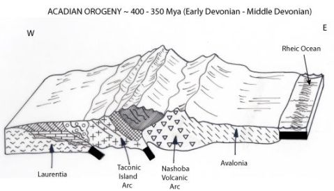
The Taconic Orogeny (mountain building process) is the first of THREE orogenies that produced the Appalachian Mountains and eventually fused all of the continents into the super continent of Pangaea (Pangea in the US).
Mountain Building
Follow me as I journey through New England showing you the evidence of how these mountains formed over hundreds of millions of years.
